A fine month with high pressure dominant - extremely dry with the temperature very marginally above average.
High pressure was dominant for significant lengthy periods during October and hence resulted in it being a very dry month. For much of the time the high pressure was centred over Scandinavia, bringing easterly winds, but with Cumbria generally sheltered from any showers and subsequently enjoying plenty of sunshine. It became slightly unsettled at mid-month after which high pressure once again became dominant.
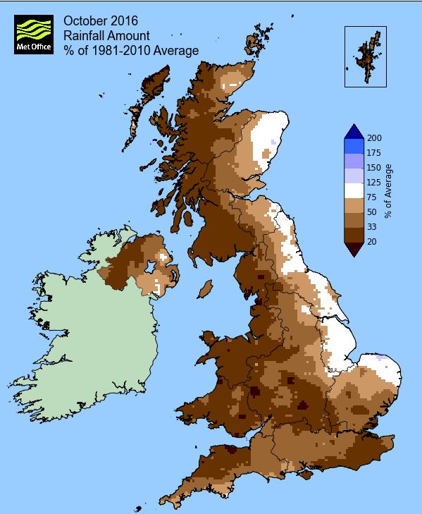
MSLP of 1023.3 Mb was +12.4 Mb above the local average for October, a significant departure from the norm' and further evidence of just how dominant and prolonged the spells of high pressure were. Consequently rainfall was insignificant, never heavy nor prolonged, albeit from mid month especially and under cloudier skies, there were occasional very light showers/spells of rain that resulted in 'Trace' amounts being recorded on a total of ten days.
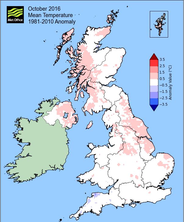
Overall a mean minimum of 5.38°c and a mean maximum of 13.40°c saw the temperature 0.3°c above the 1981-2010 average and it was the warmest October since 2014 (the 4th coldest of the 8 now recorded at this site). The highest maximum temperature recorded was 17.3°c (4th), the lowest minimum -0.2°c (25th). At Reagill the mean temperature was 9.4°c.
Rainfall of 23.9 mm (Crosby Ravensworth School 26.6 mm - CastleHowe Scar 29.9 mm and Reagill had 24.9 mm) made it the driest October yet recorded at this site (driest of 10 recorded) and was 19.2% of average for 2007-15. Locally, rainfall percentages were typically in the range of 20-30%.
At the Met' Office site at Newton Rigg, 37.4 mm (35%) made it the driest October since 2003 and in a series back to 1900 it is the 11th driest (with incomplete data for 1 year). In a series back to 1951 a mean temperature of 9.2°c is the warmest since 2014 with 33 having been warmer, 2 having the same temperature and 30 colder in that time.
Figures from the Environment Agency’s rainfall sites were, (figure in brackets being the monthly average for 1961-90) ‘Data kindly provided by the Hydrometry and Telemetry team of the Environment Agency (Penrith)’:
Kirkby Thore 27.8 mm (65.8 mm)
Brothers Water 71.5 mm (276 mm)
Nunwick Hall ??? mm (85.1 mm) is still suspected data - and
114.2 mm at Seathwaite Farm (Borrowdale - 389 mm [average for 1981-2010])
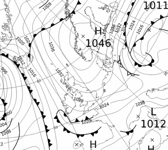
1st - 14th High pressure (HP) would dominate well into the month giving a period of dry and settled conditions. That HP remained semi static over Norway and built to 1050 Mb during the period (1035 MB at its highest here) and whilst it kept any Atlantic depressions at bay, it was responsible for drawing in an easterly breeze that felt cool at times, especially later in the period - the trade off is worth it though!
We also got to see a decent amount of sunshine during this time and we also had the first ground frosts of the season. As is often the case with this type of synoptic set-up, west was best - and we didn't have any rain of note until the 16th.
Day-time temperatures held up quite well though, any sun still being strong enough to get the temperature into the range of 15-16°c, with the 4th at 17.3°c (63.1°f) the month's warmest day when the wind came more from a SE'ly direction. Apart from overnight 4-5th, the night-time minima fell away under clear skies and whilst there were no air frosts, the 3rd recorded the season's first ground frost of -0.6°c.
From the 9th the occasional weak front ventured into the HP giving the odd spot of rain, but this was hardly of any consequence, it just broke the sequence of dry days. But now the airflow swung more E'ly, occasionally NE'ly, but the days were also much calmer and hence that drop in temperatures, the 13th dropping to 11.1°c under increasingly cloudier skies and with a number of showers. With the increasing amount of cloud the night-time minima rose accordingly to within the range of 6-7°c, average for the time of year. During the first twelve days of the month there had only been 0.9 mm of rain, falling on just three days.
15th - 18th The HP then pulled away north and would be replaced by low pressure (LP) from the SW. The LP would move north to the west of Eire (16th) and then NW (17th) to near Iceland and would introduce something less settled.
The 15th was a transitional day, still with that E'ly flow at first in the morning, veering SSW'ly in the afternoon. The day would see variable amounts of cloud but would stay dry. As the LP moved north its associated fronts would bring some rain, but this was generally in the form of showers and apart from a spell of rain in the first part of the afternoon on the 18th, tended to be overnight and very first thing in the morning.
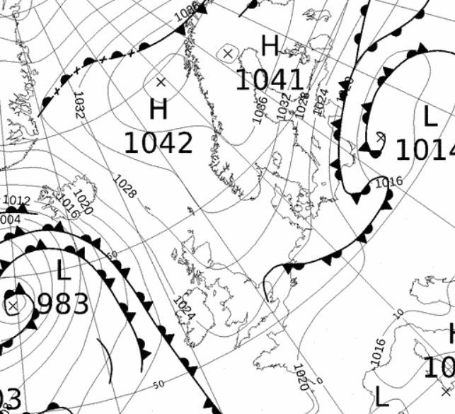
19th - 31st HP would now return and bring another spell of settled and generally dry conditions, albeit this time with more cloud. The HP would initially build to our SW, move over the UK and then repeat the set-up from earlier in the month when it ridged down from Scandinavia. Later in the period the HP would sink south to the continent and allow for a milder westerly flow before once again elongating and moving back north.
The days were generally quiet, very calm and with a nagging cloud cover that would give either the occasional light shower/spot of rain or a glance to something brighter without ever really seeing the sun. Temperatures dropped below the seasonal norm' which during the day were typically 10-12°c, with nigh-time minima determined by the amount of cloud, but did drop to 0.9°c on the 22nd, with both it and the 24th having a ground frost.
The HP would broaden out further on the 24th overnight into the 25th and with the resulting clear skies and calm conditions at -0.2°c (31.6°f) we had the first air frost of the season and then the best day in the entire period as it remained sunny until tea-time.
But it would now become somewhat overcast and milder as the HP sank further SE and introduced a brisk SW'ly flow which by the 27th would become noticeably strong. Consequently the 26-27th would be dull and overcast with the occasional spot of rain and temperatures between 12-14°c.
It became marginally milder with the change in wind direction, more so by night, the 27th having a minimum of 10.8°c and the nights through to the end of the month all above 5°c. The cloudy and dull conditions persisted through to the month's end with the nights becoming a little misty and the 31st starting off with fog that lasted into mid morning.
Rainfall totalled 23.9 mm for the month, with rain recorded on 12 days of which 4 were 'Wet days' (1.0mm +).
The Mean Temperature for the month was 9.39°c -- The Mean Max' was 13.40°c -- The Mean Min' 5.38°c.
We had 1 Air Frost in the month (year 40) -- Grass frosts totalled 5 (year 88).
The 1 foot soil temp ranged from a low of 9.3°c on the 25th to a high of 13.1°c on the 1st -- with a monthly mean of 11.2°c
The 1 meter soil temp ranged from a low of 11.0°c on the 27-28th to a high of 13.6°c on the 1st -- with a monthly mean of 12.2°c
COMPARISONS:-
* October 2016 rainfall was 19.2% of the October average for 2007 - 2015
* October 2016 was 0.28°c colder than the October average for 2009 - 2015 and 1.3°c warmer than the local long term average 1981-2010
* 2015 Jan - Oct TEMP 8.96°c -- RAIN 860.4 mm
* 2014 Jan - Oct TEMP 10.38°c -- RAIN 1159.4 mm
* 2013 Jan - Oct TEMP' 9.17°c -- RAIN 896.8 mm
* 2012 Jan - Oct TEMP' 9.08°c -- RAIN 989.2 mm
* 2011 Jan - Oct TEMP' 9.75°c -- RAIN 1016.4 mm
* 2010 Jan - Oct TEMP' 8.73°c -- RAIN 550.5 mm
* 2009 Jan - Oct TEMP' 9.76°c -- RAIN 854.3 mm
* 2008 Jan - Oct TEMP' -- RAIN 1205.0 mm
This makes the Jan' to Oct' period of 2016 0.32°c warmer than the average for 2009-15 and with 97.7% of average rainfall for 2008-15
JANUARY 2010
FEBRUARY 2010
MARCH 2010
APRIL 2010
MAY 2010
JUNE 2010
JULY 2010
AUGUST 2010
SEPTEMBER 2010
OCTOBER 2010
NOVEMBER 2010
DECEMBER 2010
JANUARY 2011
FEBRUARY 2011
MARCH 2011
APRIL 2011
MAY 2011
JUNE 2011
JULY 2011
AUGUST 2011
SEPTEMBER 2011
OCTOBER 2011
NOVEMBER 2011
DECEMBER 2011
JANUARY 2012
FEBRUARY 2012
MARCH 2012
APRIL 2012
MAY 2012
JUNE 2012
JULY 2012
AUGUST 2012
SEPTEMBER 2012
OCTOBER 2012
NOVEMBER 2012
DECEMBER 2012
SUMMER 2012
REVIEW OF 2012
JANUARY 2013
FEBRUARY 2013
MARCH 2013
APRIL 2013
MAY 2013
JUNE 2013
JULY 2013
AUGUST 2013
SEPTEMBER 2013
OCTOBER 2013
NOVEMBER 2013
DECEMBER 2013
REVIEW OF 2013
JANUARY 2014
FEBRUARY 2014
MARCH 2014
APRIL 2014
MAY 2014
JUNE 2014
JULY 2014
AUGUST 2014
SEPTEMBER 2014
OCTOBER 2014
NOVEMBER 2014
DECEMBER 2014
WINTER 2014
REVIEW OF 2014
JANUARY 2015
FEBRUARY 2015
MARCH 2015
APRIL 2015
MAY 2015
JUNE 2015
JULY 2015
AUGUST 2015
SEPTEMBER 2015
OCTOBER 2015
NOVEMBER 2015
DECEMBER 2015
REVIEW OF 2015
JANUARY 2016
FEBRUARY 2016
MARCH 2016
APRIL 2016
MAY 2016
JUNE 2016
JULY 2016
AUGUST 2016
SEPTEMBER 2016
© Darren Rogers 2016
Want to comment on this site? email